


roche saint secret le rachas

collot
User
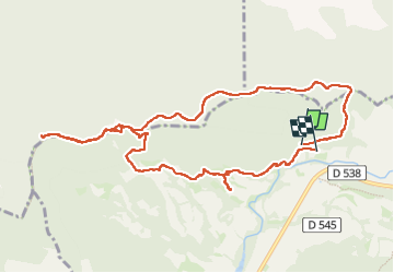

Length
11.6 km

Max alt
894 m

Uphill gradient
599 m
Km-Effort
19.6 km

Min alt
378 m

Downhill gradient
622 m
Boucle
No
Creation date :
2025-02-06 08:45:33.043
Updated on :
2025-02-06 15:19:14.909
6h33
Difficulty : Medium

FREE GPS app for hiking
 SityTrail
IGN / Geographical institutes
SityTrail Plus
The world is yours!
About
Trail Walking of 11.6 km to be discovered at Auvergne-Rhône-Alpes, Drôme, Roche-Saint-Secret-Béconne. This trail is proposed by collot.
Positioning
Country:
France
Region :
Auvergne-Rhône-Alpes
Department/Province :
Drôme
Municipality :
Roche-Saint-Secret-Béconne
Location:
Unknown
Start:(Dec)
Start:(UTM)
662221 ; 4929523 (31T) N.
Comments