


Bucey11022025PR

FPortier
User

Length
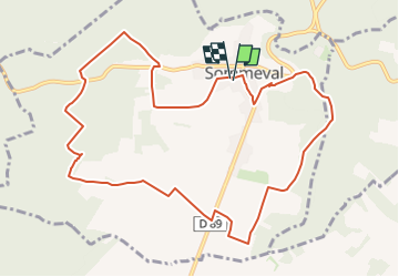
11.1 km

Max alt
298 m

Uphill gradient
257 m
Km-Effort
14.5 km

Min alt
177 m

Downhill gradient
256 m
Boucle
Yes
Creation date :
2025-02-06 16:21:22.003
Updated on :
2025-02-06 16:21:22.003
3h17
Difficulty : Difficult

FREE GPS app for hiking
 SityTrail
IGN / Geographical institutes
SityTrail Plus
The world is yours!
About
Trail Walking of 11.1 km to be discovered at Grand Est, Aube, Sommeval. This trail is proposed by FPortier.
Positioning
Country:
France
Region :
Grand Est
Department/Province :
Aube
Municipality :
Sommeval
Location:
Unknown
Start:(Dec)
Start:(UTM)
571727 ; 5334936 (31U) N.
Comments