


![Trail On foot Březová - [Ž] Točník - Veliz - Točník - okružní - Photo](https://media.geolcdn.com/t/1900/400/d7395d73-c9fd-4468-8482-1f38139bc8d9.jpeg&format=pjpeg&maxdim=2)
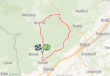
[Ž] Točník - Veliz - Točník - okružní

SityTrail - itinéraires balisés pédestres
Tous les sentiers balisés d’Europe GUIDE+

Length
23 km

Max alt
588 m

Uphill gradient
631 m
Km-Effort
31 km

Min alt
286 m

Downhill gradient
627 m
Boucle
Yes

Signpost
Creation date :
2025-02-06 19:16:41.433
Updated on :
2025-02-06 19:16:41.433
7h04
Difficulty : Difficult

FREE GPS app for hiking
 SityTrail
IGN / Geographical institutes
SityTrail Plus
The world is yours!
About
Trail On foot of 23 km to be discovered at Central Bohemia, Unknown, Březová. This trail is proposed by SityTrail - itinéraires balisés pédestres.
Description
Trail created by cz:KČT.
Photos
![Trail On foot Březová - [Ž] Točník - Veliz - Točník - okružní - Photo 1](https://media.geolcdn.com/t/2048/auto/5c7dc72d-39c6-469c-8449-423036031fed.jpeg&format=jpg&maxdim=0 "Trail On foot Březová - [Ž] Točník - Veliz - Točník - okružní - Photo 1")
![Trail On foot Březová - [Ž] Točník - Veliz - Točník - okružní - Photo 2](https://media.geolcdn.com/t/2048/auto/c990d6b7-b79c-4cc6-acad-b8aed910905d.jpeg&format=jpg&maxdim=0 "Trail On foot Březová - [Ž] Točník - Veliz - Točník - okružní - Photo 2")
![Trail On foot Březová - [Ž] Točník - Veliz - Točník - okružní - Photo 3](https://media.geolcdn.com/t/2048/auto/fd610bab-c1cc-4532-ad8f-41bc77fdcc4a.jpeg&format=jpg&maxdim=0 "Trail On foot Březová - [Ž] Točník - Veliz - Točník - okružní - Photo 3")
![Trail On foot Březová - [Ž] Točník - Veliz - Točník - okružní - Photo 4](https://media.geolcdn.com/t/2048/auto/20bca6eb-5a3b-4286-84ab-55b339105a4d.jpeg&format=jpg&maxdim=0 "Trail On foot Březová - [Ž] Točník - Veliz - Točník - okružní - Photo 4")
![Trail On foot Březová - [Ž] Točník - Veliz - Točník - okružní - Photo 5](https://media.geolcdn.com/t/2048/auto/e9e3b54d-437c-44fd-b557-bec01310eabe.jpeg&format=jpg&maxdim=0 "Trail On foot Březová - [Ž] Točník - Veliz - Točník - okružní - Photo 5")
![Trail On foot Březová - [Ž] Točník - Veliz - Točník - okružní - Photo 6](https://media.geolcdn.com/t/2048/auto/3050186f-6cb5-44ba-90b7-a944b371ca9a.jpeg&format=jpg&maxdim=0 "Trail On foot Březová - [Ž] Točník - Veliz - Točník - okružní - Photo 6")
![Trail On foot Březová - [Ž] Točník - Veliz - Točník - okružní - Photo 7](https://media.geolcdn.com/t/2048/auto/3c0d2183-98c4-42cd-b451-f90e9f70fbe0.jpeg&format=jpg&maxdim=0 "Trail On foot Březová - [Ž] Točník - Veliz - Točník - okružní - Photo 7")
![Trail On foot Březová - [Ž] Točník - Veliz - Točník - okružní - Photo 8](https://media.geolcdn.com/t/2048/auto/519d0539-6e36-4685-87cd-fa6b093de797.jpeg&format=jpg&maxdim=0 "Trail On foot Březová - [Ž] Točník - Veliz - Točník - okružní - Photo 8")
![Trail On foot Březová - [Ž] Točník - Veliz - Točník - okružní - Photo 9](https://media.geolcdn.com/t/2048/auto/083e0abc-7e87-41e2-8bda-012c89c30d16.jpeg&format=jpg&maxdim=0 "Trail On foot Březová - [Ž] Točník - Veliz - Točník - okružní - Photo 9")
![Trail On foot Březová - [Ž] Točník - Veliz - Točník - okružní - Photo 10](https://media.geolcdn.com/t/2048/auto/d7395d73-c9fd-4468-8482-1f38139bc8d9.jpeg&format=jpg&maxdim=0 "Trail On foot Březová - [Ž] Točník - Veliz - Točník - okružní - Photo 10")
Positioning
Country:
Czech Republic
Region :
Central Bohemia
Department/Province :
Unknown
Municipality :
Březová
Location:
Unknown
Start:(Dec)
Start:(UTM)
419814 ; 5527845 (33U) N.
Comments