


sbv

bernir
User
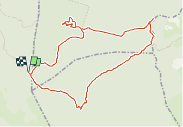

Length
12.2 km

Max alt
729 m

Uphill gradient
392 m
Km-Effort
17.4 km

Min alt
496 m

Downhill gradient
392 m
Boucle
Yes
Creation date :
2025-02-07 10:00:05.739
Updated on :
2025-02-10 18:25:13.991
3h56
Difficulty : Medium

FREE GPS app for hiking
 SityTrail
IGN / Geographical institutes
SityTrail Plus
The world is yours!
About
Trail Walking of 12.2 km to be discovered at Provence-Alpes-Côte d'Azur, Var, Signes. This trail is proposed by bernir.
Positioning
Country:
France
Region :
Provence-Alpes-Côte d'Azur
Department/Province :
Var
Municipality :
Signes
Location:
Unknown
Start:(Dec)
Start:(UTM)
737778 ; 4791074 (31T) N.
Comments