


![Trail On foot Kryry - [M] Nepomyšl - Kryry - Photo](https://media.geolcdn.com/t/1900/400/a2408f13-d402-4160-be99-95020e040a2f.jpeg&format=pjpeg&maxdim=2)
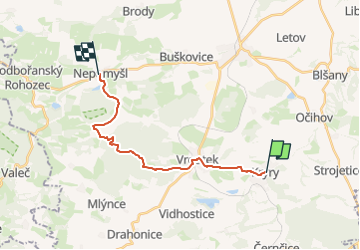
[M] Nepomyšl - Kryry

SityTrail - itinéraires balisés pédestres
Tous les sentiers balisés d’Europe GUIDE+

Length
15.2 km

Max alt
536 m

Uphill gradient
343 m
Km-Effort
19.4 km

Min alt
304 m

Downhill gradient
223 m
Boucle
No

Signpost
Creation date :
2025-02-07 15:43:13.837
Updated on :
2025-02-07 15:43:13.837
4h24
Difficulty : Easy

FREE GPS app for hiking
 SityTrail
IGN / Geographical institutes
SityTrail Plus
The world is yours!
About
Trail On foot of 15.2 km to be discovered at Northwest, Ústecký kraj, Kryry. This trail is proposed by SityTrail - itinéraires balisés pédestres.
Description
Trail created by cz:KČT.
Photos
![Trail On foot Kryry - [M] Nepomyšl - Kryry - Photo 1](https://media.geolcdn.com/t/2048/auto/6f5c41e3-8ceb-4dd3-93bd-27b3804b552c.jpeg&format=jpg&maxdim=0 "Trail On foot Kryry - [M] Nepomyšl - Kryry - Photo 1")
![Trail On foot Kryry - [M] Nepomyšl - Kryry - Photo 2](https://media.geolcdn.com/t/2048/auto/2f7257ae-2f43-4245-ae55-cf0973f83d31.jpeg&format=jpg&maxdim=0 "Trail On foot Kryry - [M] Nepomyšl - Kryry - Photo 2")
![Trail On foot Kryry - [M] Nepomyšl - Kryry - Photo 3](https://media.geolcdn.com/t/2048/auto/f3419177-9878-4d80-8747-082256fe7d32.jpeg&format=jpg&maxdim=0 "Trail On foot Kryry - [M] Nepomyšl - Kryry - Photo 3")
![Trail On foot Kryry - [M] Nepomyšl - Kryry - Photo 4](https://media.geolcdn.com/t/2048/auto/4a6e5147-698a-4f85-9739-89c9cabcd296.jpeg&format=jpg&maxdim=0 "Trail On foot Kryry - [M] Nepomyšl - Kryry - Photo 4")
![Trail On foot Kryry - [M] Nepomyšl - Kryry - Photo 5](https://media.geolcdn.com/t/2048/auto/24e700a4-205b-4173-a230-0df3c1f0097a.jpeg&format=jpg&maxdim=0 "Trail On foot Kryry - [M] Nepomyšl - Kryry - Photo 5")
![Trail On foot Kryry - [M] Nepomyšl - Kryry - Photo 6](https://media.geolcdn.com/t/2048/auto/16ad9afd-9ffb-44c8-bf45-7649c3043acb.jpeg&format=jpg&maxdim=0 "Trail On foot Kryry - [M] Nepomyšl - Kryry - Photo 6")
![Trail On foot Kryry - [M] Nepomyšl - Kryry - Photo 7](https://media.geolcdn.com/t/2048/auto/0c07e811-b950-4b27-8ae0-21a635b81910.jpeg&format=jpg&maxdim=0 "Trail On foot Kryry - [M] Nepomyšl - Kryry - Photo 7")
![Trail On foot Kryry - [M] Nepomyšl - Kryry - Photo 8](https://media.geolcdn.com/t/2048/auto/5e3b1c80-0934-4144-a6cc-2280f8a0bb5e.jpeg&format=jpg&maxdim=0 "Trail On foot Kryry - [M] Nepomyšl - Kryry - Photo 8")
![Trail On foot Kryry - [M] Nepomyšl - Kryry - Photo 9](https://media.geolcdn.com/t/2048/auto/a2408f13-d402-4160-be99-95020e040a2f.jpeg&format=jpg&maxdim=0 "Trail On foot Kryry - [M] Nepomyšl - Kryry - Photo 9")
![Trail On foot Kryry - [M] Nepomyšl - Kryry - Photo 10](https://media.geolcdn.com/t/2048/auto/076142d8-7b27-4dc0-bfd7-a96817a4cf57.jpeg&format=jpg&maxdim=0 "Trail On foot Kryry - [M] Nepomyšl - Kryry - Photo 10")
Positioning
Country:
Czech Republic
Region :
Northwest
Department/Province :
Ústecký kraj
Municipality :
Kryry
Location:
Unknown
Start:(Dec)
Start:(UTM)
387666 ; 5559214 (33U) N.
Comments