


![Trail On foot Krásná Lípa - [M] Brtnický okruh - Photo](https://media.geolcdn.com/t/1900/400/2c25ed32-bc80-4d66-bfb8-31499feb073b.jpeg&format=pjpeg&maxdim=2)
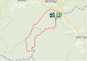
[M] Brtnický okruh

SityTrail - itinéraires balisés pédestres
Tous les sentiers balisés d’Europe GUIDE+

Length
6.6 km

Max alt
472 m

Uphill gradient
143 m
Km-Effort
8.5 km

Min alt
353 m

Downhill gradient
141 m
Boucle
Yes

Signpost
Creation date :
2025-02-07 17:48:03.244
Updated on :
2025-02-07 17:48:03.244
1h55
Difficulty : Easy

FREE GPS app for hiking
 SityTrail
IGN / Geographical institutes
SityTrail Plus
The world is yours!
About
Trail On foot of 6.6 km to be discovered at Northwest, Ústecký kraj, Krásná Lípa. This trail is proposed by SityTrail - itinéraires balisés pédestres.
Description
Trail created by cz:KČT.
Photos
![Trail On foot Krásná Lípa - [M] Brtnický okruh - Photo 1](https://media.geolcdn.com/t/2048/auto/8cdc9c14-64a0-4ff5-ae5a-d7ab8b5ed844.jpeg&format=jpg&maxdim=0 "Trail On foot Krásná Lípa - [M] Brtnický okruh - Photo 1")
![Trail On foot Krásná Lípa - [M] Brtnický okruh - Photo 2](https://media.geolcdn.com/t/2048/auto/bfce5a69-2a46-4f71-ad21-48b9c31bf645.jpeg&format=jpg&maxdim=0 "Trail On foot Krásná Lípa - [M] Brtnický okruh - Photo 2")
![Trail On foot Krásná Lípa - [M] Brtnický okruh - Photo 3](https://media.geolcdn.com/t/2048/auto/b21aed0f-a2f1-48fc-bf66-da1e0836fd33.jpeg&format=jpg&maxdim=0 "Trail On foot Krásná Lípa - [M] Brtnický okruh - Photo 3")
![Trail On foot Krásná Lípa - [M] Brtnický okruh - Photo 4](https://media.geolcdn.com/t/2048/auto/ba598d4e-7277-44f0-b27d-a2bbc1d40b1b.jpeg&format=jpg&maxdim=0 "Trail On foot Krásná Lípa - [M] Brtnický okruh - Photo 4")
![Trail On foot Krásná Lípa - [M] Brtnický okruh - Photo 5](https://media.geolcdn.com/t/2048/auto/b130377b-40bc-4767-99a1-e74ece10b92d.jpeg&format=jpg&maxdim=0 "Trail On foot Krásná Lípa - [M] Brtnický okruh - Photo 5")
![Trail On foot Krásná Lípa - [M] Brtnický okruh - Photo 6](https://media.geolcdn.com/t/2048/auto/193efe1b-1c5d-48f7-a648-2041e01f4605.jpeg&format=jpg&maxdim=0 "Trail On foot Krásná Lípa - [M] Brtnický okruh - Photo 6")
![Trail On foot Krásná Lípa - [M] Brtnický okruh - Photo 7](https://media.geolcdn.com/t/2048/auto/167d2249-c613-4fc9-a73f-b1d74a550f65.jpeg&format=jpg&maxdim=0 "Trail On foot Krásná Lípa - [M] Brtnický okruh - Photo 7")
![Trail On foot Krásná Lípa - [M] Brtnický okruh - Photo 8](https://media.geolcdn.com/t/2048/auto/3fc766ba-40e3-4dfd-8b95-558ec1f06cb1.jpeg&format=jpg&maxdim=0 "Trail On foot Krásná Lípa - [M] Brtnický okruh - Photo 8")
![Trail On foot Krásná Lípa - [M] Brtnický okruh - Photo 9](https://media.geolcdn.com/t/2048/auto/2c25ed32-bc80-4d66-bfb8-31499feb073b.jpeg&format=jpg&maxdim=0 "Trail On foot Krásná Lípa - [M] Brtnický okruh - Photo 9")
![Trail On foot Krásná Lípa - [M] Brtnický okruh - Photo 10](https://media.geolcdn.com/t/2048/auto/abe37001-ec73-48a4-8352-202dfee83ec9.jpeg&format=jpg&maxdim=0 "Trail On foot Krásná Lípa - [M] Brtnický okruh - Photo 10")
Positioning
Country:
Czech Republic
Region :
Northwest
Department/Province :
Ústecký kraj
Municipality :
Krásná Lípa
Location:
Unknown
Start:(Dec)
Start:(UTM)
461038 ; 5643204 (33U) N.
Comments