


2025-02-11-marche-douce-Villepreux-Rennemoulin

Rando MLC
User
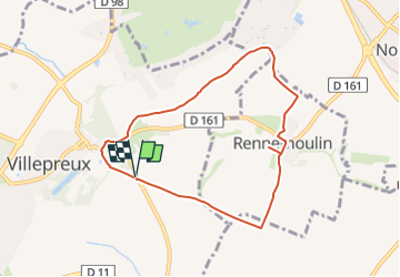

Length
7.2 km

Max alt
123 m

Uphill gradient
79 m
Km-Effort
8.2 km

Min alt
89 m

Downhill gradient
79 m
Boucle
Yes
Creation date :
2025-02-08 10:54:15.685
Updated on :
2025-02-08 10:55:01.918
1h52
Difficulty : Medium

FREE GPS app for hiking
 SityTrail
IGN / Geographical institutes
SityTrail Plus
The world is yours!
About
Trail Walking of 7.2 km to be discovered at Ile-de-France, Yvelines, Villepreux. This trail is proposed by Rando MLC.
Positioning
Country:
France
Region :
Ile-de-France
Department/Province :
Yvelines
Municipality :
Villepreux
Location:
Unknown
Start:(Dec)
Start:(UTM)
428131 ; 5409124 (31U) N.
Comments