


fléchage adeps Plancenoit

BOUMA
User
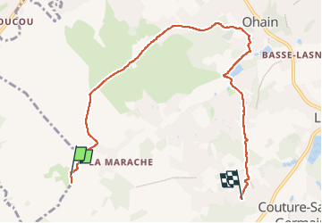

Length
7.2 km

Max alt
127 m

Uphill gradient
106 m
Km-Effort
8.6 km

Min alt
77 m

Downhill gradient
96 m
Boucle
No
Creation date :
2025-02-08 10:30:19.28
Updated on :
2025-02-08 12:55:19.071
2h24
Difficulty : Very easy

FREE GPS app for hiking
 SityTrail
IGN / Geographical institutes
SityTrail Plus
The world is yours!
About
Trail Walking of 7.2 km to be discovered at Wallonia, Walloon Brabant, Waterloo. This trail is proposed by BOUMA.
Positioning
Country:
Belgium
Region :
Wallonia
Department/Province :
Walloon Brabant
Municipality :
Waterloo
Location:
Unknown
Start:(Dec)
Start:(UTM)
601343 ; 5615110 (31U) N.
Comments