


merignat 1

robert gallet
User
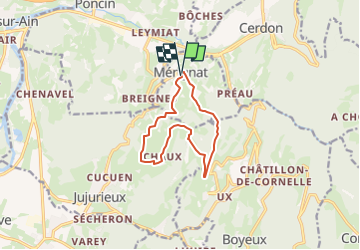

Length
10.3 km

Max alt
587 m

Uphill gradient
338 m
Km-Effort
14.8 km

Min alt
429 m

Downhill gradient
344 m
Boucle
Yes
Creation date :
2025-02-09 08:30:55.022
Updated on :
2025-02-09 08:31:27.746
3h22
Difficulty : Difficult

FREE GPS app for hiking
 SityTrail
IGN / Geographical institutes
SityTrail Plus
The world is yours!
About
Trail Walking of 10.3 km to be discovered at Auvergne-Rhône-Alpes, Ain, Mérignat. This trail is proposed by robert gallet.
Positioning
Country:
France
Region :
Auvergne-Rhône-Alpes
Department/Province :
Ain
Municipality :
Mérignat
Location:
Unknown
Start:(Dec)
Start:(UTM)
688476 ; 5104572 (31T) N.
Comments