merignat 2

robert gallet
User
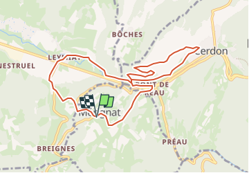

Length
9.6 km

Max alt
443 m

Uphill gradient
290 m
Km-Effort
13.5 km

Min alt
277 m

Downhill gradient
298 m
Boucle
Yes
Creation date :
2025-02-09 08:42:45.837
Updated on :
2025-02-09 08:43:12.231
3h04
Difficulty : Difficult

FREE GPS app for hiking
 SityTrail
IGN / Geographical institutes
SityTrail Plus
The world is yours!
About
Trail Walking of 9.6 km to be discovered at Auvergne-Rhône-Alpes, Ain, Mérignat. This trail is proposed by robert gallet.
Positioning
Country:
France
Region :
Auvergne-Rhône-Alpes
Department/Province :
Ain
Municipality :
Mérignat
Location:
Unknown
Start:(Dec)
Start:(UTM)
688419 ; 5104590 (31T) N.
Comments