


Perronas

ash
User
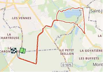

Length
12 km

Max alt
283 m

Uphill gradient
132 m
Km-Effort
13.7 km

Min alt
222 m

Downhill gradient
132 m
Boucle
Yes
Creation date :
2025-02-09 09:03:20.0
Updated on :
2025-02-09 11:26:58.763

FREE GPS app for hiking
 SityTrail
IGN / Geographical institutes
SityTrail Plus
The world is yours!
About
Trail of 12 km to be discovered at Auvergne-Rhône-Alpes, Ain, Péronnas. This trail is proposed by ash.
Description
Forêt seillon
Positioning
Country:
France
Region :
Auvergne-Rhône-Alpes
Department/Province :
Ain
Municipality :
Péronnas
Location:
Unknown
Start:(Dec)
Start:(UTM)
672336 ; 5115686 (31T) N.
Comments