


Peyroux de Champ sur tarentaine

Michelraimbault
User
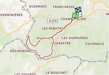

Length
7.3 km

Max alt
578 m

Uphill gradient
202 m
Km-Effort
9.9 km

Min alt
458 m

Downhill gradient
201 m
Boucle
No
Creation date :
2025-02-09 12:40:26.723
Updated on :
2025-02-09 15:24:48.887
2h16
Difficulty : Medium

FREE GPS app for hiking
 SityTrail
IGN / Geographical institutes
SityTrail Plus
The world is yours!
About
Trail Walking of 7.3 km to be discovered at Auvergne-Rhône-Alpes, Cantal, Champs-sur-Tarentaine-Marchal. This trail is proposed by Michelraimbault.
Positioning
Country:
France
Region :
Auvergne-Rhône-Alpes
Department/Province :
Cantal
Municipality :
Champs-sur-Tarentaine-Marchal
Location:
Champs-sur-Tarentaine
Start:(Dec)
Start:(UTM)
464687 ; 5026556 (31T) N.
Comments