


Bathernay

brigitBB26
User
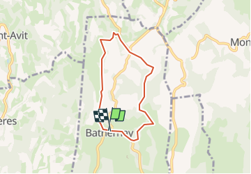

Length
5.8 km

Max alt
465 m

Uphill gradient
162 m
Km-Effort
8 km

Min alt
290 m

Downhill gradient
183 m
Boucle
Yes
Creation date :
2025-02-10 18:10:17.654
Updated on :
2025-02-10 18:13:51.13
1h49
Difficulty : Medium

FREE GPS app for hiking
 SityTrail
IGN / Geographical institutes
SityTrail Plus
The world is yours!
About
Trail Walking of 5.8 km to be discovered at Auvergne-Rhône-Alpes, Drôme, Bathernay. This trail is proposed by brigitBB26.
Description
Boucle au départ de l'église
Positioning
Country:
France
Region :
Auvergne-Rhône-Alpes
Department/Province :
Drôme
Municipality :
Bathernay
Location:
Unknown
Start:(Dec)
Start:(UTM)
656723 ; 5004890 (31T) N.
Comments