


Maredsous par evelyne

AnneBeguin
User
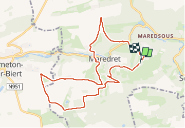

Length
9.7 km

Max alt
283 m

Uphill gradient
240 m
Km-Effort
12.9 km

Min alt
174 m

Downhill gradient
249 m
Boucle
Yes
Creation date :
2025-02-11 12:31:32.271
Updated on :
2025-02-12 08:01:49.768
2h45
Difficulty : Difficult

FREE GPS app for hiking
 SityTrail
IGN / Geographical institutes
SityTrail Plus
The world is yours!
About
Trail Walking of 9.7 km to be discovered at Wallonia, Namur, Anhée. This trail is proposed by AnneBeguin.
Positioning
Country:
Belgium
Region :
Wallonia
Department/Province :
Namur
Municipality :
Anhée
Location:
Unknown
Start:(Dec)
Start:(UTM)
625650 ; 5573329 (31U) N.
Comments