


SityTrail - Olloy-20240401-rando lundi Pâques PM

asblicare
User
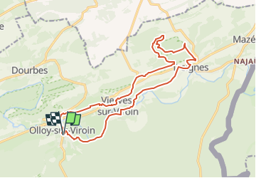

Length
16.8 km

Max alt
233 m

Uphill gradient
397 m
Km-Effort
22 km

Min alt
130 m

Downhill gradient
397 m
Boucle
Yes
Creation date :
2025-02-11 15:58:25.833
Updated on :
2025-02-11 16:00:21.062
5h00
Difficulty : Medium

FREE GPS app for hiking
 SityTrail
IGN / Geographical institutes
SityTrail Plus
The world is yours!
About
Trail On foot of 16.8 km to be discovered at Wallonia, Namur, Viroinval. This trail is proposed by asblicare.
Description
Au départ du Centre Européen à Olloy, circuit en boucle vert Viervers, Treignes, Matignolle par Ardenne et retour par Calestienne.
Positioning
Country:
Belgium
Region :
Wallonia
Department/Province :
Namur
Municipality :
Viroinval
Location:
Unknown
Start:(Dec)
Start:(UTM)
615060 ; 5547787 (31U) N.
Comments