


2025_02_14_Chevreuse

maxEA65
User
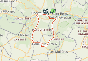

Length
10.9 km

Max alt
179 m

Uphill gradient
156 m
Km-Effort
13 km

Min alt
76 m

Downhill gradient
157 m
Boucle
Yes
Creation date :
2025-02-12 07:48:53.928
Updated on :
2025-02-12 07:50:03.894
2h57
Difficulty : Difficult

FREE GPS app for hiking
 SityTrail
IGN / Geographical institutes
SityTrail Plus
The world is yours!
About
Trail Walking of 10.9 km to be discovered at Ile-de-France, Yvelines, Chevreuse. This trail is proposed by maxEA65.
Positioning
Country:
France
Region :
Ile-de-France
Department/Province :
Yvelines
Municipality :
Chevreuse
Location:
Unknown
Start:(Dec)
Start:(UTM)
430542 ; 5395039 (31U) N.
Comments