Trail Walking Saint-Rémy-lès-Chevreuse - SityTrail - Chevincourt Montabé jour - Photo

SityTrail - Chevincourt Montabé jour

© OpenStreetMap contributors
Length
Length
11.9 km
Max alt
Max alt
175 m
Uphill gradient
Uphill gradient
229 m
Km-Effort
Km-Effort  
15 km
Min alt
Min alt
74 m
Downhill gradient
Downhill gradient
229 m
Boucle
Boucle
Yes
Creation date :
2025-02-13 14:30:17.204
Updated on :
2025-04-11 14:50:10.78

(0 Reviews)

Walking
Walking
3h24
Difficulty : Medium

Scan this QR Code to open this trail in the SityTrail application

FREE GPS app for hiking

Logo SityTrail SityTrail

IGN / Geographical institutes

Download SityTrail from the App Store Download SityTrail from Google Play

Logo SityTrail SityTrail Plus

The world is yours!

Download SityTrail from the App Store Download SityTrail from Google Play Download SityTrail on Huawei AppGallery

About

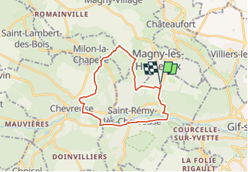
Trail Walking of 11.9 km to be discovered at Ile-de-France, Yvelines, Saint-Rémy-lès-Chevreuse. This trail is proposed by Rando MLC.

Description

GR655, gare de Courcelle . PNR, Ferme du Grand Ragonant, le Bois de Berrier . nb, Soligny, GR11, Montabé . GR655, Domaine de Saint Paul . nb Forêt départementale de Méridon . GR11, Chevreuse, les Petits Ponts , Château de la Madeleine . PNR, carrefour de Milon (13 km, tables et Abri), le Bois de Florence, forêt départementale de Champfally, la Côte de Rhodon, bois départemental de Beauplan, le Petit Chevincourt, Courcelle . GR655, le Val Courcelle..

Elevation profile

Positioning

Country:
France
Region :
Ile-de-France
Department/Province :
Yvelines
Municipality :
Saint-Rémy-lès-Chevreuse
Location:
Unknown
Start:(UTM)
432720 ; 5396316 (31U) N.


Close
My subscriptions