


Roussas, Roubi.

collot
User
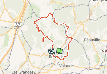

Length
18.5 km

Max alt
378 m

Uphill gradient
449 m
Km-Effort
24 km

Min alt
111 m

Downhill gradient
456 m
Boucle
Yes
Creation date :
2025-01-26 08:44:43.061
Updated on :
2025-03-23 10:44:35.493
5h33
Difficulty : Medium

FREE GPS app for hiking
 SityTrail
IGN / Geographical institutes
SityTrail Plus
The world is yours!
About
Trail Walking of 18.5 km to be discovered at Auvergne-Rhône-Alpes, Drôme, Roussas. This trail is proposed by collot.
Description
rando variée, bien sympathique.
Positioning
Country:
France
Region :
Auvergne-Rhône-Alpes
Department/Province :
Drôme
Municipality :
Roussas
Location:
Unknown
Start:(Dec)
Start:(UTM)
643356 ; 4921149 (31T) N.
Comments