


mercurey - chassey le camp. variante

XavierFaidix
User
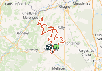

Length
32 km

Max alt
431 m

Uphill gradient
952 m
Km-Effort
45 km

Min alt
225 m

Downhill gradient
954 m
Boucle
Yes
Creation date :
2025-02-13 12:22:38.845
Updated on :
2025-02-13 21:06:49.354
2h43
Difficulty : Medium

FREE GPS app for hiking
 SityTrail
IGN / Geographical institutes
SityTrail Plus
The world is yours!
About
Trail Mountain bike of 32 km to be discovered at Bourgogne-Franche-Comté, Saône-et-Loire, Mercurey. This trail is proposed by XavierFaidix.
Description
VAE
Positioning
Country:
France
Region :
Bourgogne-Franche-Comté
Department/Province :
Saône-et-Loire
Municipality :
Mercurey
Location:
Bourgneuf-Val-d'Or
Start:(Dec)
Start:(UTM)
631316 ; 5188070 (31T) N.
Comments