


Les travers du Caroux

ARVIEU
User

Length
12.2 km

Max alt
1069 m

Uphill gradient
695 m
Km-Effort
21 km

Min alt
705 m

Downhill gradient
693 m
Boucle
Yes
Creation date :
2025-02-14 06:16:40.633
Updated on :
2025-02-14 06:20:41.004
5h00
Difficulty : Medium

FREE GPS app for hiking
 SityTrail
IGN / Geographical institutes
SityTrail Plus
The world is yours!
About
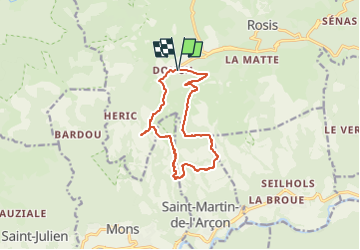
Trail Walking of 12.2 km to be discovered at Occitania, Hérault, Rosis. This trail is proposed by ARVIEU.
Description
Randonnée au départ de Douch, en passant par le Roc du Caroux, Font Salesse, le Sentier des Gardes, la piste des Biterrois et retour par le Rocher de Sarrazine.
Photos

Points of interest


Positioning
Country:
France
Region :
Occitania
Department/Province :
Hérault
Municipality :
Rosis
Location:
Unknown
Start:(Dec)
Start:(UTM)
498025 ; 4828645 (31T) N.
Comments