


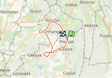
pressiat 14/02

robert gallet
User

Length
9.5 km

Max alt
352 m

Uphill gradient
193 m
Km-Effort
12.1 km

Min alt
243 m

Downhill gradient
198 m
Boucle
Yes
Creation date :
2025-02-14 09:53:25.523
Updated on :
2025-02-14 09:53:51.963
2h44
Difficulty : Easy

FREE GPS app for hiking
 SityTrail
IGN / Geographical institutes
SityTrail Plus
The world is yours!
About
Trail On foot of 9.5 km to be discovered at Auvergne-Rhône-Alpes, Ain, Val-Revermont. This trail is proposed by robert gallet.
Positioning
Country:
France
Region :
Auvergne-Rhône-Alpes
Department/Province :
Ain
Municipality :
Val-Revermont
Location:
Unknown
Start:(Dec)
Start:(UTM)
683639 ; 5132793 (31T) N.
Comments