


pk Costebelle

jmheydorff
User
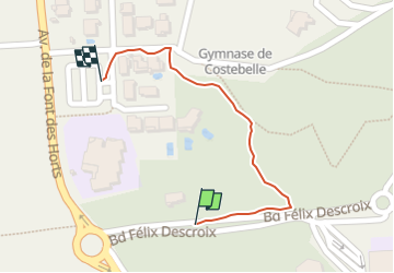

Length
330 m

Max alt
74 m

Uphill gradient
0 m
Km-Effort
376 m

Min alt
59 m

Downhill gradient
14 m
Boucle
Yes
Creation date :
2025-02-15 08:53:56.541
Updated on :
2025-02-15 09:00:18.926
6m
Difficulty : Easy

FREE GPS app for hiking
 SityTrail
IGN / Geographical institutes
SityTrail Plus
The world is yours!
About
Trail Walking of 330 m to be discovered at Provence-Alpes-Côte d'Azur, Var, Hyères. This trail is proposed by jmheydorff.
Positioning
Country:
France
Region :
Provence-Alpes-Côte d'Azur
Department/Province :
Var
Municipality :
Hyères
Location:
Unknown
Start:(Dec)
Start:(UTM)
265851 ; 4775724 (32T) N.
Comments