


Routo aixAiguilles

taguette
User

Length
14.8 km

Max alt
306 m

Uphill gradient
229 m
Km-Effort
17.9 km

Min alt
182 m

Downhill gradient
230 m
Boucle
No
Creation date :
2025-02-15 08:29:21.388
Updated on :
2025-02-15 13:01:40.728
4h31
Difficulty : Difficult

FREE GPS app for hiking
 SityTrail
IGN / Geographical institutes
SityTrail Plus
The world is yours!
About
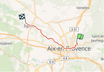
Trail Walking of 14.8 km to be discovered at Provence-Alpes-Côte d'Azur, Bouches-du-Rhône, Aix-en-Provence. This trail is proposed by taguette.
Positioning
Country:
France
Region :
Provence-Alpes-Côte d'Azur
Department/Province :
Bouches-du-Rhône
Municipality :
Aix-en-Provence
Location:
Unknown
Start:(Dec)
Start:(UTM)
699150 ; 4823601 (31T) N.
Comments