


Belledonne boucle lac d’ Arsel

c.gourme
User
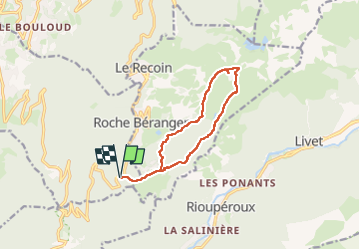

Length
11.6 km

Max alt
2248 m

Uphill gradient
655 m
Km-Effort
20 km

Min alt
1620 m

Downhill gradient
656 m
Boucle
Yes
Creation date :
2025-02-15 07:53:21.0
Updated on :
2025-02-15 14:58:49.337
7h04
Difficulty : Difficult

FREE GPS app for hiking
 SityTrail
IGN / Geographical institutes
SityTrail Plus
The world is yours!
About
Trail Snowshoes of 11.6 km to be discovered at Auvergne-Rhône-Alpes, Isère, Vaulnaveys-le-Haut. This trail is proposed by c.gourme.
Positioning
Country:
France
Region :
Auvergne-Rhône-Alpes
Department/Province :
Isère
Municipality :
Vaulnaveys-le-Haut
Location:
Unknown
Start:(Dec)
Start:(UTM)
725736 ; 4997986 (31T) N.
Comments