


Beure

cmike39
User
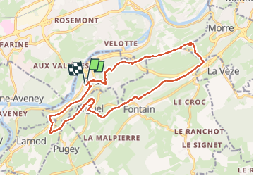

Length
18.8 km

Max alt
500 m

Uphill gradient
553 m
Km-Effort
26 km

Min alt
238 m

Downhill gradient
553 m
Boucle
Yes
Creation date :
2025-02-15 08:55:54.59
Updated on :
2025-02-15 16:40:46.15
7h41
Difficulty : Very difficult

FREE GPS app for hiking
 SityTrail
IGN / Geographical institutes
SityTrail Plus
The world is yours!
About
Trail Walking of 18.8 km to be discovered at Bourgogne-Franche-Comté, Doubs, Beure. This trail is proposed by cmike39.
Positioning
Country:
France
Region :
Bourgogne-Franche-Comté
Department/Province :
Doubs
Municipality :
Beure
Location:
Unknown
Start:(Dec)
Start:(UTM)
272862 ; 5232539 (32T) N.
Comments