


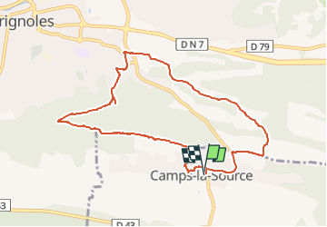
Autour de Camps la Source by DAL.

dany83ynad
User

Length
9.9 km

Max alt
435 m

Uphill gradient
265 m
Km-Effort
13.4 km

Min alt
233 m

Downhill gradient
265 m
Boucle
Yes
Creation date :
2025-02-15 16:56:53.237
Updated on :
2025-02-16 17:25:02.453
3h02
Difficulty : Medium

FREE GPS app for hiking
 SityTrail
IGN / Geographical institutes
SityTrail Plus
The world is yours!
About
Trail Walking of 9.9 km to be discovered at Provence-Alpes-Côte d'Azur, Var, Camps-la-Source. This trail is proposed by dany83ynad.
Positioning
Country:
France
Region :
Provence-Alpes-Côte d'Azur
Department/Province :
Var
Municipality :
Camps-la-Source
Location:
Unknown
Start:(Dec)
Start:(UTM)
264799 ; 4807695 (32T) N.
Comments