


Margny

pascha
User
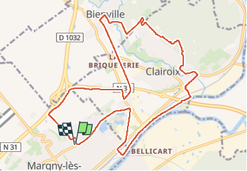

Length
12 km

Max alt
100 m

Uphill gradient
163 m
Km-Effort
14.1 km

Min alt
24 m

Downhill gradient
163 m
Boucle
Yes
Creation date :
2025-02-16 07:59:59.0
Updated on :
2025-02-16 11:23:54.142

FREE GPS app for hiking
 SityTrail
IGN / Geographical institutes
SityTrail Plus
The world is yours!
About
Trail of 12 km to be discovered at Hauts-de-France, Oise, Margny-lès-Compiègne. This trail is proposed by pascha.
Positioning
Country:
France
Region :
Hauts-de-France
Department/Province :
Oise
Municipality :
Margny-lès-Compiègne
Location:
Unknown
Start:(Dec)
Start:(UTM)
487128 ; 5475180 (31U) N.
Comments