


aa

chuck
User
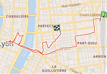

Length
5.9 km

Max alt
186 m

Uphill gradient
73 m
Km-Effort
6.9 km

Min alt
164 m

Downhill gradient
75 m
Boucle
No
Creation date :
2025-02-16 14:06:52.934
Updated on :
2025-02-16 16:06:40.989
1h59
Difficulty : Medium

FREE GPS app for hiking
 SityTrail
IGN / Geographical institutes
SityTrail Plus
The world is yours!
About
Trail Walking of 5.9 km to be discovered at Auvergne-Rhône-Alpes, Métropole de Lyon, Lyon. This trail is proposed by chuck.
Positioning
Country:
France
Region :
Auvergne-Rhône-Alpes
Department/Province :
Métropole de Lyon
Municipality :
Lyon
Location:
Lyon 3e Arrondissement
Start:(Dec)
Start:(UTM)
644580 ; 5069319 (31T) N.
Comments