


gallargues

Monica Lailhacar
User
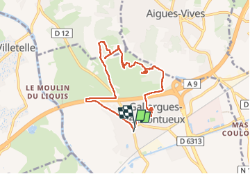

Length
8.6 km

Max alt
66 m

Uphill gradient
100 m
Km-Effort
9.9 km

Min alt
14 m

Downhill gradient
96 m
Boucle
Yes
Creation date :
2025-02-16 13:17:11.699
Updated on :
2025-02-16 16:17:31.842
2h58
Difficulty : Easy

FREE GPS app for hiking
 SityTrail
IGN / Geographical institutes
SityTrail Plus
The world is yours!
About
Trail Walking of 8.6 km to be discovered at Occitania, Gard, Gallargues-le-Montueux. This trail is proposed by Monica Lailhacar.
Description
pas de balisage, on y va au pif
passage ingrat qui longe L'A9
joli bois de Cabassus, superbe voie romaine
Positioning
Country:
France
Region :
Occitania
Department/Province :
Gard
Municipality :
Gallargues-le-Montueux
Location:
Unknown
Start:(Dec)
Start:(UTM)
594154 ; 4841299 (31T) N.
Comments