


Tanneron

soca
User
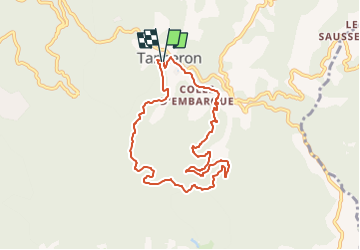

Length
8.6 km

Max alt
408 m

Uphill gradient
353 m
Km-Effort
13.4 km

Min alt
192 m

Downhill gradient
361 m
Boucle
Yes
Creation date :
2025-02-16 18:00:50.323
Updated on :
2025-02-16 18:02:14.331
4h30
Difficulty : Medium

FREE GPS app for hiking
 SityTrail
IGN / Geographical institutes
SityTrail Plus
The world is yours!
About
Trail Walking of 8.6 km to be discovered at Provence-Alpes-Côte d'Azur, Var, Tanneron. This trail is proposed by soca.
Positioning
Country:
France
Region :
Provence-Alpes-Côte d'Azur
Department/Province :
Var
Municipality :
Tanneron
Location:
Unknown
Start:(Dec)
Start:(UTM)
328422 ; 4828500 (32T) N.
Comments