


bavilliers la chapelle et le fort

Evelyne3
User
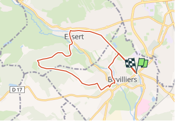

Length
8.1 km

Max alt
467 m

Uphill gradient
178 m
Km-Effort
10.5 km

Min alt
345 m

Downhill gradient
177 m
Boucle
Yes
Creation date :
2025-02-17 10:16:59.802
Updated on :
2025-02-17 10:18:37.95
2h22
Difficulty : Medium

FREE GPS app for hiking
 SityTrail
IGN / Geographical institutes
SityTrail Plus
The world is yours!
About
Trail Walking of 8.1 km to be discovered at Bourgogne-Franche-Comté, Territoire-de-Belfort, Bavilliers. This trail is proposed by Evelyne3.
Description
premiere
Positioning
Country:
France
Region :
Bourgogne-Franche-Comté
Department/Province :
Territoire-de-Belfort
Municipality :
Bavilliers
Location:
Unknown
Start:(Dec)
Start:(UTM)
337690 ; 5276712 (32T) N.
Comments