


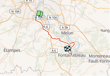
2015-06-21-Bondoufle Fontainebleau 50km

Lucquiaud
User

Length
52 km

Max alt
155 m

Uphill gradient
479 m
Km-Effort
58 km

Min alt
46 m

Downhill gradient
483 m
Boucle
No
Creation date :
2018-09-15 15:06:11.217
Updated on :
2018-09-15 15:06:11.242
3h51
Difficulty : Easy

FREE GPS app for hiking
 SityTrail
IGN / Geographical institutes
SityTrail Plus
The world is yours!
About
Trail Mountain bike of 52 km to be discovered at Ile-de-France, Essonne, Bondoufle. This trail is proposed by Lucquiaud.
Positioning
Country:
France
Region :
Ile-de-France
Department/Province :
Essonne
Municipality :
Bondoufle
Location:
Unknown
Start:(Dec)
Start:(UTM)
454087 ; 5384741 (31U) N.
Comments