


boucle Fratin vers Lahage

julu
User
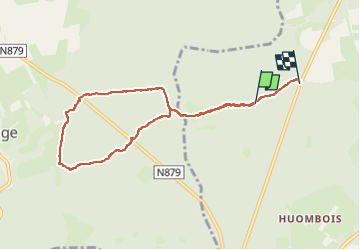

Length
7.3 km

Max alt
385 m

Uphill gradient
90 m
Km-Effort
8.5 km

Min alt
350 m

Downhill gradient
96 m
Boucle
No
Creation date :
2025-02-17 13:52:36.623
Updated on :
2025-02-17 16:18:23.554
2h00
Difficulty : Easy

FREE GPS app for hiking
 SityTrail
IGN / Geographical institutes
SityTrail Plus
The world is yours!
About
Trail Walking of 7.3 km to be discovered at Wallonia, Luxembourg, Étalle. This trail is proposed by julu.

Positioning
Country:
Belgium
Region :
Wallonia
Department/Province :
Luxembourg
Municipality :
Étalle
Location:
Sainte-Marie
Start:(Dec)
Start:(UTM)
683717 ; 5502926 (31U) N.
Comments