


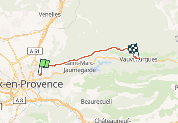
Routo Aix Vauvenargues

taguette
User

Length
15 km

Max alt
618 m

Uphill gradient
424 m
Km-Effort
20 km

Min alt
240 m

Downhill gradient
279 m
Boucle
No
Creation date :
2025-02-18 07:37:05.504
Updated on :
2025-02-18 11:15:33.588
3h35
Difficulty : Very difficult

FREE GPS app for hiking
 SityTrail
IGN / Geographical institutes
SityTrail Plus
The world is yours!
About
Trail Walking of 15 km to be discovered at Provence-Alpes-Côte d'Azur, Bouches-du-Rhône, Aix-en-Provence. This trail is proposed by taguette.
Positioning
Country:
France
Region :
Provence-Alpes-Côte d'Azur
Department/Province :
Bouches-du-Rhône
Municipality :
Aix-en-Provence
Location:
Unknown
Start:(Dec)
Start:(UTM)
699115 ; 4823623 (31T) N.
Comments