


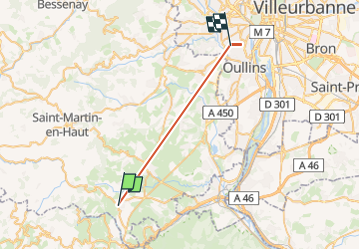
Aqueduc Cabaniere

cbr69110
User

Length
24 km

Max alt
479 m

Uphill gradient
488 m
Km-Effort
31 km

Min alt
180 m

Downhill gradient
697 m
Boucle
No
Creation date :
2025-02-18 11:05:08.861
Updated on :
2025-02-18 15:24:27.018
4h18
Difficulty : Very difficult

FREE GPS app for hiking
 SityTrail
IGN / Geographical institutes
SityTrail Plus
The world is yours!
About
Trail Walking of 24 km to be discovered at Auvergne-Rhône-Alpes, Rhône, Chabanière. This trail is proposed by cbr69110.
Description
balade
Positioning
Country:
France
Region :
Auvergne-Rhône-Alpes
Department/Province :
Rhône
Municipality :
Chabanière
Location:
Saint-Maurice-sur-Dargoire
Start:(Dec)
Start:(UTM)
627199 ; 5048897 (31T) N.
Comments