


sortie vtt du 20062015

fabwin
User GUIDE
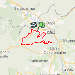

Length
21 km

Max alt
586 m

Uphill gradient
539 m
Km-Effort
28 km

Min alt
303 m

Downhill gradient
538 m
Boucle
Yes
Creation date :
2015-06-21 00:00:00.0
Updated on :
2015-06-21 00:00:00.0
1h50
Difficulty : Difficult

FREE GPS app for hiking
 SityTrail
IGN / Geographical institutes
SityTrail Plus
The world is yours!
About
Trail Mountain bike of 21 km to be discovered at Grand Est, Vosges, Raon-l'Étape. This trail is proposed by fabwin.
Description
Pierre d'appel avec Séb & Maxime
Positioning
Country:
France
Region :
Grand Est
Department/Province :
Vosges
Municipality :
Raon-l'Étape
Location:
Unknown
Start:(Dec)
Start:(UTM)
339072 ; 5362315 (32U) N.
Comments
Top