


ternand

vaud
User
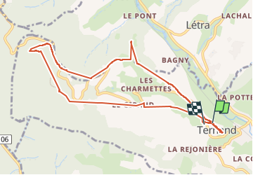

Length
10.7 km

Max alt
666 m

Uphill gradient
471 m
Km-Effort
17 km

Min alt
319 m

Downhill gradient
487 m
Boucle
Yes
Creation date :
2025-02-19 09:30:04.867
Updated on :
2025-02-19 14:34:48.133
1h35
Difficulty : Difficult

FREE GPS app for hiking
 SityTrail
IGN / Geographical institutes
SityTrail Plus
The world is yours!
About
Trail Walking of 10.7 km to be discovered at Auvergne-Rhône-Alpes, Rhône, Ternand. This trail is proposed by vaud.
Positioning
Country:
France
Region :
Auvergne-Rhône-Alpes
Department/Province :
Rhône
Municipality :
Ternand
Location:
Unknown
Start:(Dec)
Start:(UTM)
618401 ; 5089125 (31T) N.
Comments