


L'Ayré bis

yvesdelafforest
User
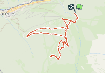

Length
6.7 km

Max alt
1876 m

Uphill gradient
405 m
Km-Effort
12.1 km

Min alt
1507 m

Downhill gradient
405 m
Boucle
Yes
Creation date :
2025-02-20 09:48:09.383
Updated on :
2025-02-20 15:17:33.275
5h28
Difficulty : Very easy

FREE GPS app for hiking
 SityTrail
IGN / Geographical institutes
SityTrail Plus
The world is yours!
About
Trail Touring skiing of 6.7 km to be discovered at Occitania, Hautespyrenees, Barèges. This trail is proposed by yvesdelafforest.
Positioning
Country:
France
Region :
Occitania
Department/Province :
Hautespyrenees
Municipality :
Barèges
Location:
Unknown
Start:(Dec)
Start:(UTM)
261794 ; 4753384 (31T) N.
Comments