


tanneron 25

bernir
User
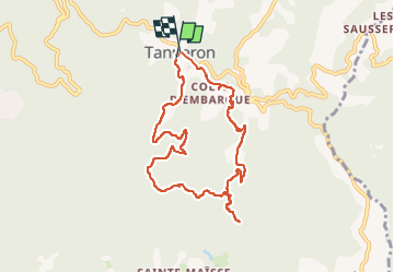

Length
9.6 km

Max alt
408 m

Uphill gradient
328 m
Km-Effort
13.9 km

Min alt
201 m

Downhill gradient
320 m
Boucle
Yes
Creation date :
2025-02-20 08:56:10.02
Updated on :
2025-02-21 11:41:57.427
3h09
Difficulty : Medium

FREE GPS app for hiking
 SityTrail
IGN / Geographical institutes
SityTrail Plus
The world is yours!
About
Trail Walking of 9.6 km to be discovered at Provence-Alpes-Côte d'Azur, Var, Tanneron. This trail is proposed by bernir.
Photos


Positioning
Country:
France
Region :
Provence-Alpes-Côte d'Azur
Department/Province :
Var
Municipality :
Tanneron
Location:
Unknown
Start:(Dec)
Start:(UTM)
328466 ; 4828478 (32T) N.
Comments