


Pré de cinq sous

ajd26
User
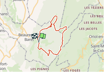

Length
14.7 km

Max alt
1289 m

Uphill gradient
881 m
Km-Effort
26 km

Min alt
508 m

Downhill gradient
880 m
Boucle
Yes
Creation date :
2025-02-20 08:00:09.0
Updated on :
2025-02-22 16:32:16.04
4h48
Difficulty : Very difficult

FREE GPS app for hiking
 SityTrail
IGN / Geographical institutes
SityTrail Plus
The world is yours!
About
Trail Walking of 14.7 km to be discovered at Auvergne-Rhône-Alpes, Drôme, Beauregard-Baret. This trail is proposed by ajd26.
Description
attention la montée au pas de l'Aulagnier est trés raide
à ne pas faire en descendant par temps humide
Photos


Positioning
Country:
France
Region :
Auvergne-Rhône-Alpes
Department/Province :
Drôme
Municipality :
Beauregard-Baret
Location:
Unknown
Start:(Dec)
Start:(UTM)
673258 ; 4984382 (31T) N.
Comments