


pierrefitte douaniers G3 2025

LouisROGER
User GUIDE
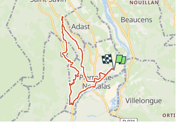

Length
9.2 km

Max alt
755 m

Uphill gradient
478 m
Km-Effort
15.5 km

Min alt
466 m

Downhill gradient
477 m
Boucle
Yes
Creation date :
2025-02-21 08:04:54.776
Updated on :
2025-02-21 13:43:13.896
5h37
Difficulty : Difficult

FREE GPS app for hiking
 SityTrail
IGN / Geographical institutes
SityTrail Plus
The world is yours!
About
Trail Walking of 9.2 km to be discovered at Occitania, Hautespyrenees, Pierrefitte-Nestalas. This trail is proposed by LouisROGER.
Positioning
Country:
France
Region :
Occitania
Department/Province :
Hautespyrenees
Municipality :
Pierrefitte-Nestalas
Location:
Unknown
Start:(Dec)
Start:(UTM)
739165 ; 4760786 (30T) N.
Comments