


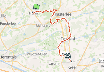
Tielen - Geel

kimpej
User

Length
26 km

Max alt
42 m

Uphill gradient
148 m
Km-Effort
28 km

Min alt
14 m

Downhill gradient
141 m
Boucle
No
Creation date :
2025-02-21 08:30:08.012
Updated on :
2025-05-03 14:08:01.975
6h17
Difficulty : Very difficult

FREE GPS app for hiking
 SityTrail
IGN / Geographical institutes
SityTrail Plus
The world is yours!
About
Trail Walking of 26 km to be discovered at Flanders, Antwerp, Kasterlee. This trail is proposed by kimpej.
Positioning
Country:
Belgium
Region :
Flanders
Department/Province :
Antwerp
Municipality :
Kasterlee
Location:
Tielen
Start:(Dec)
Start:(UTM)
632265 ; 5678501 (31U) N.
Comments