


dps Écromagny

margotte
User

Length
8.2 km

Max alt
457 m

Uphill gradient
138 m
Km-Effort
10 km

Min alt
360 m

Downhill gradient
139 m
Boucle
Yes
Creation date :
2025-02-21 11:57:54.09
Updated on :
2025-02-21 14:18:19.015
1h53
Difficulty : Easy

FREE GPS app for hiking
 SityTrail
IGN / Geographical institutes
SityTrail Plus
The world is yours!
About
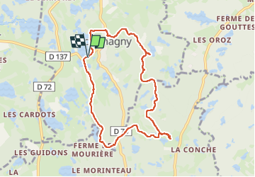
Trail Walking of 8.2 km to be discovered at Bourgogne-Franche-Comté, Haute-Saône, Écromagny. This trail is proposed by margotte.
Positioning
Country:
France
Region :
Bourgogne-Franche-Comté
Department/Province :
Haute-Saône
Municipality :
Écromagny
Location:
Unknown
Start:(Dec)
Start:(UTM)
317214 ; 5295935 (32T) N.
Comments