


2 eme

hgm
User
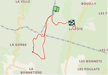

Length
7.4 km

Max alt
1351 m

Uphill gradient
157 m
Km-Effort
10.2 km

Min alt
986 m

Downhill gradient
389 m
Boucle
No
Creation date :
2025-02-20 09:53:45.419
Updated on :
2025-02-22 08:36:10.213
44h23
Difficulty : Medium

FREE GPS app for hiking
 SityTrail
IGN / Geographical institutes
SityTrail Plus
The world is yours!
About
Trail Walking of 7.4 km to be discovered at Auvergne-Rhône-Alpes, Isère, Lans-en-Vercors. This trail is proposed by hgm.
Positioning
Country:
France
Region :
Auvergne-Rhône-Alpes
Department/Province :
Isère
Municipality :
Lans-en-Vercors
Location:
Unknown
Start:(Dec)
Start:(UTM)
700300 ; 4997890 (31T) N.
Comments