


Chartreuse tour du Néron

c.gourme
User
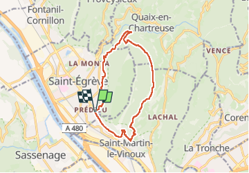

Length
13.4 km

Max alt
755 m

Uphill gradient
681 m
Km-Effort
22 km

Min alt
205 m

Downhill gradient
680 m
Boucle
Yes
Creation date :
2025-02-22 07:59:35.0
Updated on :
2025-02-22 14:21:40.275
5h31
Difficulty : Medium

FREE GPS app for hiking
 SityTrail
IGN / Geographical institutes
SityTrail Plus
The world is yours!
About
Trail Walking of 13.4 km to be discovered at Auvergne-Rhône-Alpes, Isère, Saint-Égrève. This trail is proposed by c.gourme.
Positioning
Country:
France
Region :
Auvergne-Rhône-Alpes
Department/Province :
Isère
Municipality :
Saint-Égrève
Location:
Unknown
Start:(Dec)
Start:(UTM)
711236 ; 5011117 (31T) N.
Comments