


Lac de Bannac

PascalBanide
User
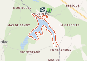

Length
5 km

Max alt
356 m

Uphill gradient
50 m
Km-Effort
5.7 km

Min alt
332 m

Downhill gradient
49 m
Boucle
Yes
Creation date :
2025-02-22 15:12:31.0
Updated on :
2025-02-22 17:56:19.169

FREE GPS app for hiking
 SityTrail
IGN / Geographical institutes
SityTrail Plus
The world is yours!
About
Trail of 5 km to be discovered at Occitania, Aveyron, Martiel. This trail is proposed by PascalBanide.
Positioning
Country:
France
Region :
Occitania
Department/Province :
Aveyron
Municipality :
Martiel
Location:
Unknown
Start:(Dec)
Start:(UTM)
411458 ; 4915095 (31T) N.
Comments