


2025-02-22_19h31m35_ccm25_51

mthomas30
User
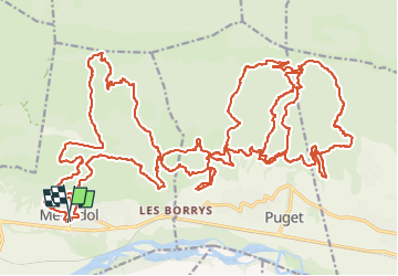

Length
50 km

Max alt
588 m

Uphill gradient
1980 m
Km-Effort
77 km

Min alt
154 m

Downhill gradient
1976 m
Boucle
Yes
Creation date :
2025-02-22 18:31:35.514
Updated on :
2025-02-24 07:00:50.682
5h19
Difficulty : Very difficult

FREE GPS app for hiking
 SityTrail
IGN / Geographical institutes
SityTrail Plus
The world is yours!
About
Trail Mountain bike of 50 km to be discovered at Provence-Alpes-Côte d'Azur, Vaucluse, Mérindol. This trail is proposed by mthomas30.
Description
51km dur dur.
Positioning
Country:
France
Region :
Provence-Alpes-Côte d'Azur
Department/Province :
Vaucluse
Municipality :
Mérindol
Location:
Unknown
Start:(Dec)
Start:(UTM)
677298 ; 4846912 (31T) N.
Comments