


Épineuse

pascha
User
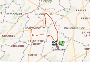

Length
11.4 km

Max alt
150 m

Uphill gradient
141 m
Km-Effort
13.3 km

Min alt
78 m

Downhill gradient
143 m
Boucle
Yes
Creation date :
2025-02-23 08:00:59.0
Updated on :
2025-02-23 10:40:23.675

FREE GPS app for hiking
 SityTrail
IGN / Geographical institutes
SityTrail Plus
The world is yours!
About
Trail of 11.4 km to be discovered at Hauts-de-France, Oise, Épineuse. This trail is proposed by pascha.
Positioning
Country:
France
Region :
Hauts-de-France
Department/Province :
Oise
Municipality :
Épineuse
Location:
Unknown
Start:(Dec)
Start:(UTM)
467684 ; 5471709 (31U) N.
Comments