


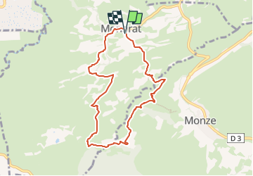
Montirat - Bordeneuve - La Magdeleine

Combaut11
User

Length
8.2 km

Max alt
270 m

Uphill gradient
190 m
Km-Effort
10.8 km

Min alt
174 m

Downhill gradient
189 m
Boucle
Yes
Creation date :
2025-02-23 11:10:01.787
Updated on :
2025-02-23 11:12:24.577
2h26
Difficulty : Medium

FREE GPS app for hiking
 SityTrail
IGN / Geographical institutes
SityTrail Plus
The world is yours!
About
Trail Walking of 8.2 km to be discovered at Occitania, Aude, Montirat. This trail is proposed by Combaut11.
Positioning
Country:
France
Region :
Occitania
Department/Province :
Aude
Municipality :
Montirat
Location:
Unknown
Start:(Dec)
Start:(UTM)
454512 ; 4780053 (31T) N.
Comments