


Mongressin

APhilippe
User

Length
9.5 km

Max alt
69 m

Uphill gradient
71 m
Km-Effort
10.4 km

Min alt
50 m

Downhill gradient
73 m
Boucle
No
Creation date :
2025-02-21 09:01:02.956
Updated on :
2025-02-23 11:11:54.953
2h30
Difficulty : Easy

FREE GPS app for hiking
 SityTrail
IGN / Geographical institutes
SityTrail Plus
The world is yours!
About
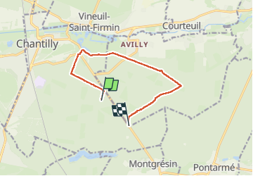
Trail Walking of 9.5 km to be discovered at Hauts-de-France, Oise, Chantilly. This trail is proposed by APhilippe.
Positioning
Country:
France
Region :
Hauts-de-France
Department/Province :
Oise
Municipality :
Chantilly
Location:
Unknown
Start:(Dec)
Start:(UTM)
463215 ; 5447047 (31U) N.
Comments